HO CHI MINH TRAIL THROUGH QUANG BINH HERITAGE LAND
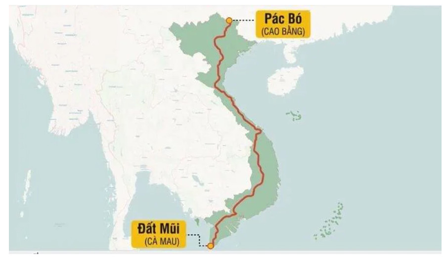
Along with National Highway 1A, the North-South Expressway and Vietnam's coastal road, the Ho Chi Minh Road is four vital traffic roads running from North to South. With a total length of 3,167km passing through 30 provinces and cities, starting from Cao Bang through the Central and Central Highlands provinces, Southeast and ending in Ca Mau.
Circumstances of the road's birth
The 1954 Geneva Agreement temporarily divided our country into two regions. The North entered the stage of building up to socialism, while at the same time playing the role of rearguard for the Southern front line fighting to regain the government under the control of the puppet government and US imperialism. The increasing demands of the Southern front posed an urgent need for a transportation route to ensure human and material resources for the front line.
The trail through the Truong Son range has been used since the resistance war against the French. Carriages, baskets of food and ammunition followed this narrow road to the fronts from North to South, but could not meet the support for the growing Southern revolution.
Faced with the new situation, on May 19th, 1959 - coinciding with President Ho Chi Minh's birthday - the Central Party Politburo decided to establish a "Special Working Group", initially staffed with 500 officers and soldiers. Soldiers are responsible for building strategic support lines, transferring human and material resources from the North to serve the Southern revolution, as well as the Lao and Cambodian revolutions.
Born in May 1959, the Union was given the name of Group 559. The road was opened on Ho Chi Minh's birthday, so it was named Ho Chi Minh Road. From here, Truong Son Road was named "Ho Chi Minh Road", starting to go down in history as a living legend about the will, intelligence, and bravery of the Vietnamese army and people.
The road of spirit and solidarity and friendship
After a period of surveying, the plan to open a road to the West began to be implemented, in which the opening of a road across the Vietnam - Laos border at the Ta Cu mountain terrace, with an altitude of over 700m, was urgently implemented. When requesting road expansion, the arterial route starting from Western Nghe An to Quang Binh was "flipped" to Western Truong Son, passing through the three provinces of Quang Binh, Kham Muon, and Savannakhet. The people of Lao tribes actively contributed their contributions to Vietnamese officers and soldiers to pave the way. The Lao People's Party Central Committee met and proposed the policy "Find every way to help Truong Son soldiers pave the way". Laotian tribal people in the provinces of Kham Muon and Savannakhet have voluntarily moved their homes and abandoned their fields to serve the new route, ensuring the "closest and easiest to go" requirement. The result of the contributions and sacrifices of the Lao army and people, especially the decision to agree to allow Vietnam to "turn over" the Truong Son Road to the West to continue connecting the "lifeline" for Laos. Southern battlefield, at the same time meeting the request for support for the battlefields of Laos and Cambodia, defeating the plots of the anti-revolutionary forces of the three Indochina countries. Thanks to timely support, the Lao revolution had steady development steps, and the Vietnam - Laos fighting alliance was strengthened. With its important strategic position and great contributions to the liberation struggle of the peoples, the Ho Chi Minh Trail is a shining symbol of special fighting solidarity against the common enemy not only of the two peoples. Vietnam - Laos ethnic group but also the three countries Vietnam - Laos - Cambodia, is the thread connecting the battlefields of the three Indochina countries, creating a sustainable continuous system, is one of the great achievements of military technology of XX century.
The Ho Chi Minh trail passes through Quang Binh province
The Ho Chi Minh section passing through Quang Binh province has a length of 285 km, running along the East Sea coast, through 6 districts, towns, and cities, including Tuyen Hoa, Quang Trach, Bo Trach, Le Thuy, Quang Ninh, and Dong Hoi. Quang Binh province has both vertical and horizontal routes. The vertical route has Road 15A, which runs parallel to National Highway 1A, through Quang Binh territory from Tan Duc (Tuyen Hoa district) to Khe Gat (Xuan Trach commune, Bo Trach district) and continues to divide into two branches: The western branch from Khe Gat to Dan Chu slope (Ho Village, Le Thuy district) and the eastern branch to Ben Quan (Vinh Linh district, Quang Tri province).
During the resistance war against the US, the Ho Chi Minh road through Quang Binh was one of the vital routes to support the South. Millions of tons of weapons, ammunition, food, medicine, and tens of thousands of officers, soldiers, and young volunteers passed through this route to the front lines.
After many years of fierce war, the Ho Chi Minh trail through Quang Binh was heavily damaged by enemy bombs. After the country was unified, this route was restored, upgraded and expanded. Currently, this route has become an important traffic route of Quang Binh province, connecting districts, towns, and cities in the province.

In addition to its traffic significance, the Ho Chi Minh trail through Quang Binh is also an important historical and cultural relic of the province. On this route, there are many historical-cultural relics associated with the nation's historical events, such as: Eight Ladies cave, Xuan Son ferry, Tam Co cave, Legendary Khe Gat Field Battle Airport,... as well as famous tourist destinations such as Phong Nha Cave, Thien Duong Cave,...
With great historical, cultural, and socio-economic values, the Ho Chi Minh trail through Quang Binh has been ranked as a special national historical relic by the Ministry of Culture, Sports and Tourism.
Today, the Ho Chi Minh trail through Quang Binh is not only an important traffic route but also an attractive tourist destination of the province. Visitors to Quang Binh can visit and learn about the nation's history and culture through historical and cultural relics associated with this route.